You can download a pdf version here
Stormy Weather!
I hope this finds you all well, and keeping both dry and upright in this very wild weather. It looks to be far more settled for when we meet again on March 1st.
What a week it has been, with 3 named storms following on so closely to each other. We think this is highly unusual, but when we look at recent meteorological records, this has happened before in February, alongside the warmest, wettest years recorded in the last 10 years. Climate change is here.
I thought it would be interesting to remind ourselves about the basis of clouds and windy weather. Forecasting has become a distinct science, but recognising some types of cloud can be both fun and useful, especially if venturing out on a spring walk or early picnic...
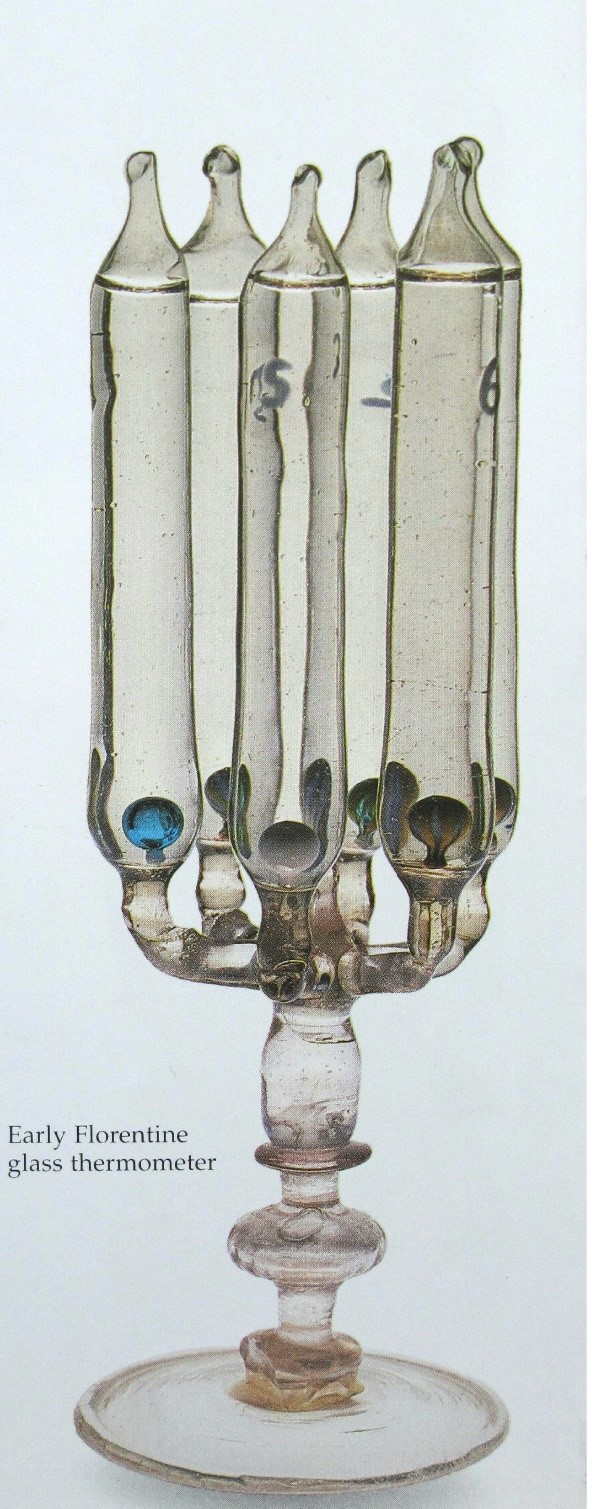
Firstly though, here is an image of a truly beautiful glass thermometer, made in Florence in the 17th Century, at the time of Galileo. The coloured glass balls within the tubes, which are full of water, rise and fall depending on the ambient temperature. I include it simply due to its beauty. We need more of that in life I reckon.
Aristotle devised a theory of ‘atmospheric exhalations’, but it was Luke Howard, a pharmacist and amateur meteorologist in 1802, who devised a simple classification system for clouds. The Latin names he chose are still used internationally today. He ordered them into 3 main families of cloud: Cirrus, meaning hair or fibre, Cumulus, meaning pile or heap, and Stratus, meaning layer or sheet. Constable painted a series of 100 cloud studies, all aided by his annotated copy of Howard’s original classification of clouds.
A brief summary of the First International Cloud Atlas of 1896:
A. Upper Clouds, average altitude of 29,500ft: Cirrus and Cirro-stratus
B. Intermediate Clouds, average altitude of 9.840 to 23,000ft: Cirro- cumulus, Alto-cumulus and Alto-stratus
C. Lower Clouds, average altitude of 6,500ft: Strato-cumulus and Nimbus.
This has been augmented over time, so we now have 14 species and 9 variations within the 10 general cloud classifications, all still with Latin names. We don’t need to remember them all, but they are wonderfully descriptive if you fancy taking a peek at them all on the Met Office website...
I will focus on the main clouds and conditions that bring us such wet weather.
The Jet Stream, as we have explored before, has a major influence on our weather. A band of enormously strong winds in the upper atmosphere, between the troposphere and stratosphere, they have a key role in the development and movement of low-pressure systems. The troposphere is where all our weather occurs as this layer contains the most water vapour.
The Jet Stream is usually at its most intense in winter, as these winds are generated by the huge temperature differences at high altitude, which causes very strong pressure gradients. Warm air has a higher pressure than cold air, so air flows from areas of high pressure to low pressure. The more contrast there is between the two areas of pressure, the greater the wind strength. You may well have seen graphics of the Jet Stream winds right over the UK during this very stormy weather. They can reach up to 200 miles an hour!

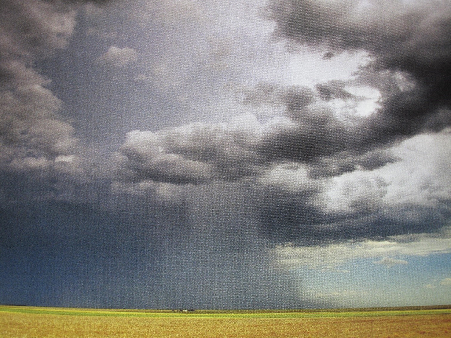
Cumulus clouds are very common, white and fluffy and usually indicating good weather on bright days. Cumulus Congesta are the largest forms of cumulus clouds, with the main upward, convective cells still outlined with rounded tops. The image here shows how large these clouds can be, up to a mile or two high if there is enough warm, moist air to allow them to grow upwards. They can grow to enormous height if they are over the sea, as they still gain heat from the sea even after sunset. This image also shows they haven’t started freezing at their highest point yet, after which they cease growing upwards and become cumulonimbus clouds, capable of producing torrential downpours.

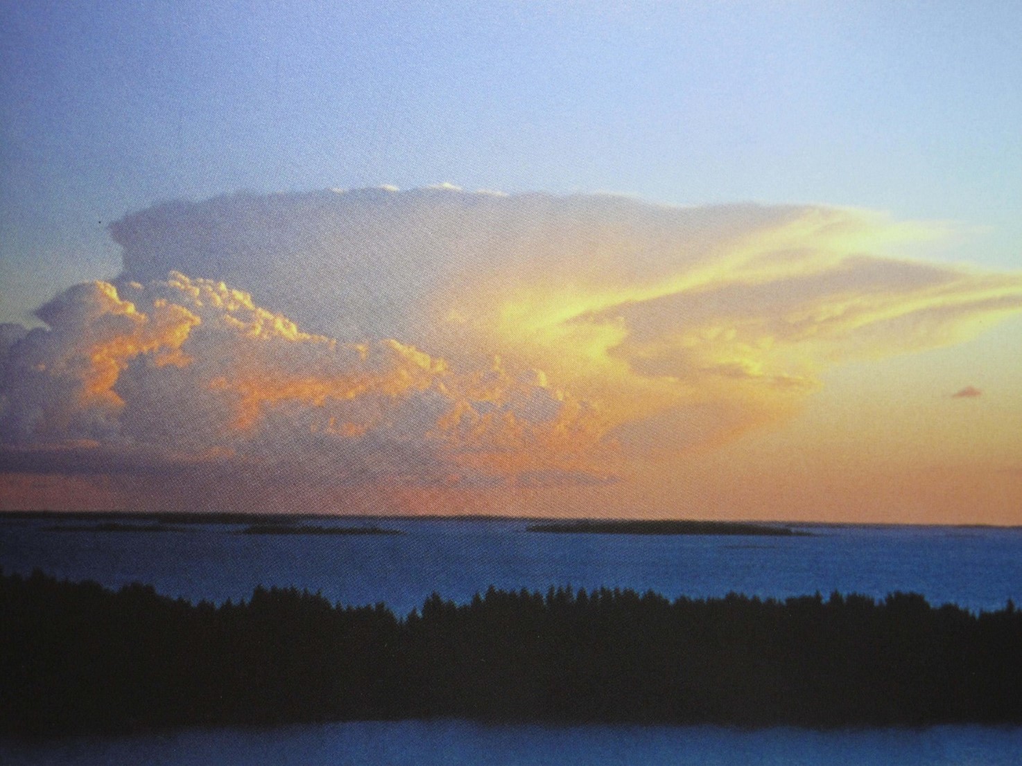
These massive clouds develop from the previous Congesta form. Calvus means bald, so it is the name given to the Congesta cloud as soon as it starts to lose the familiar ‘cauliflower’ top, and becomes smoother and more consolidated. They often have a typical anvil top, but all of them can turn into violent thunderstorms.
This is the most stormy phase, with C. Capillatus clouds producing torrential rain, squally showers, lightning and hail. Both of the cumulonimbus clouds contain very strong currents within them, with high water content. These are the clouds that all aircraft avoid, as they create powerful turbulence and the water can easily freeze in thick layers on the cold metal of the plane. Planes also take off and land into the wind, which is why they have such trouble landing in storms, where wind direction is both very strong and changeable.
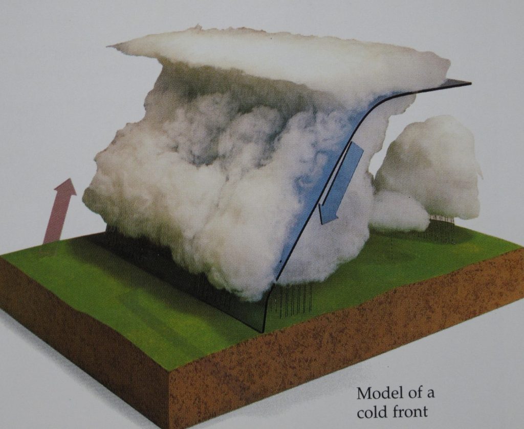
Cumulonimbus clouds build up along a cold front. This is not the same as forgetting to put your thick jumper on, or not doing your coat up in winter....
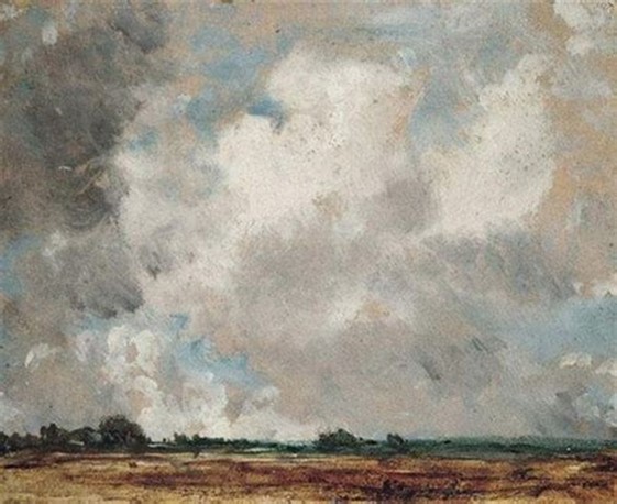
A cold front occurs when cold polar air cuts in sharply beneath warmer, moist air that is rising. Winds along the front are gusty, and arranged in a clear edge called a squall line. Heavy rain will fall in many places along the cold front. Behind the front, the air gets colder and pressure rises, while powerful updraughts carry more moisture up so high it then turns to ice. The icy tops of the clouds are blown into a sharp wedge shape by the high-level winds. You can see this in the model of a cold front, shown in the picture below.
The storms can be very intense, but tend to be short lived, often leaving colder air behind, and some showers may still fall after the cold front has passed.
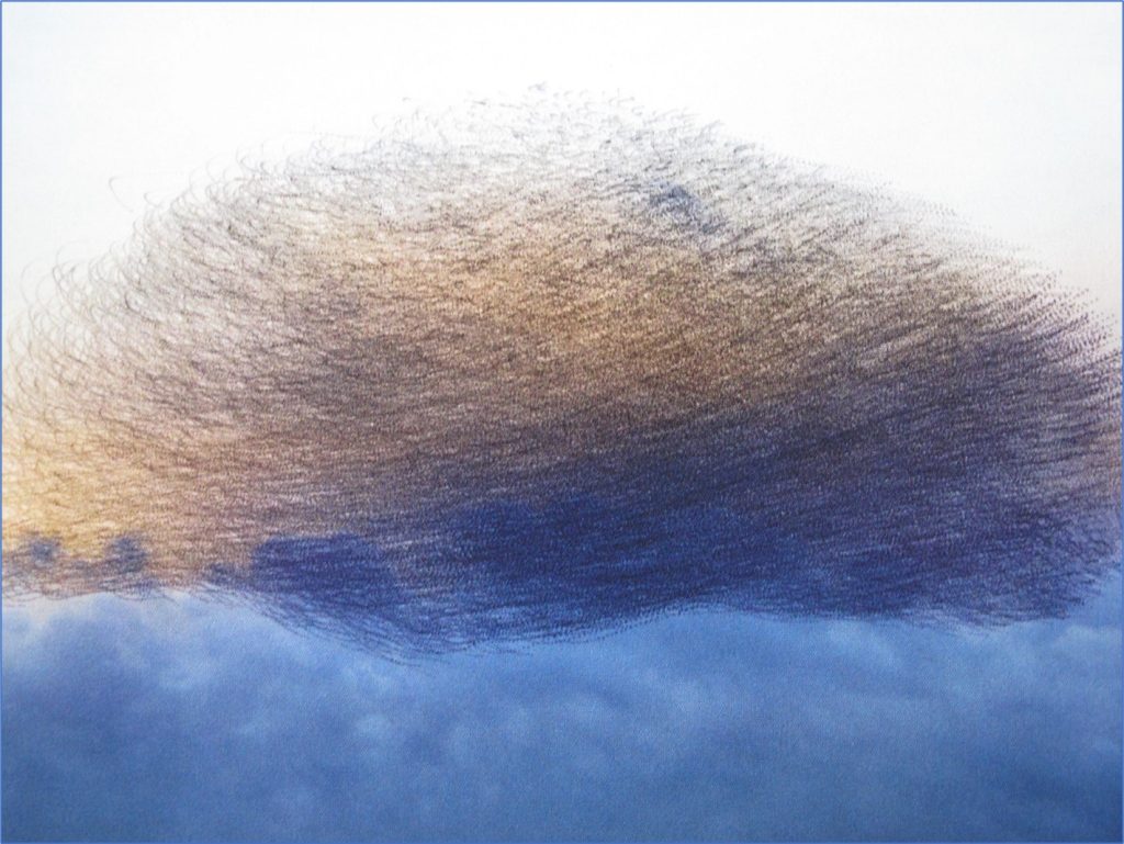
So, inching forward to the meteorological start of Spring, on the very day we meet next - March 1st (2.00 pm) - I will finish this last of these 3 winter nature newsletters with a fabulous photograph of a starling murmuration. Taken by Kathryn Cooper, it is a reminder that these storms are also hugely dangerous for wildlife, including this vast colony of small, fluttering starlings. Phew.
Take care and I am so looking forward to us all meeting up again. Yippee.
Warmest wishes,
Jan xxx