
Here are Jan Flamank's Nature Notes for March 2021. Click on each photo to see a larger photo on a new page. For a downloadable pdf version click the link below the text.
As I have done in some of our lovely nature sessions at the library, this month I am going to focus in a bit more detail on just one subject: our somewhat capricious but fascinating weather.
I love watching a decent BBC weather forecast, but often want the presenters to explain far more about the underlying global forces and conditions that drive the many changes we see through the seasons. So, I am giving myself a temporary meteorological role here, which will hopefully illuminate some of the complexities of our weather. We have had some glorious sunrises and sunsets recently, aided by dust blown across us from the Sahara on Southern winds.
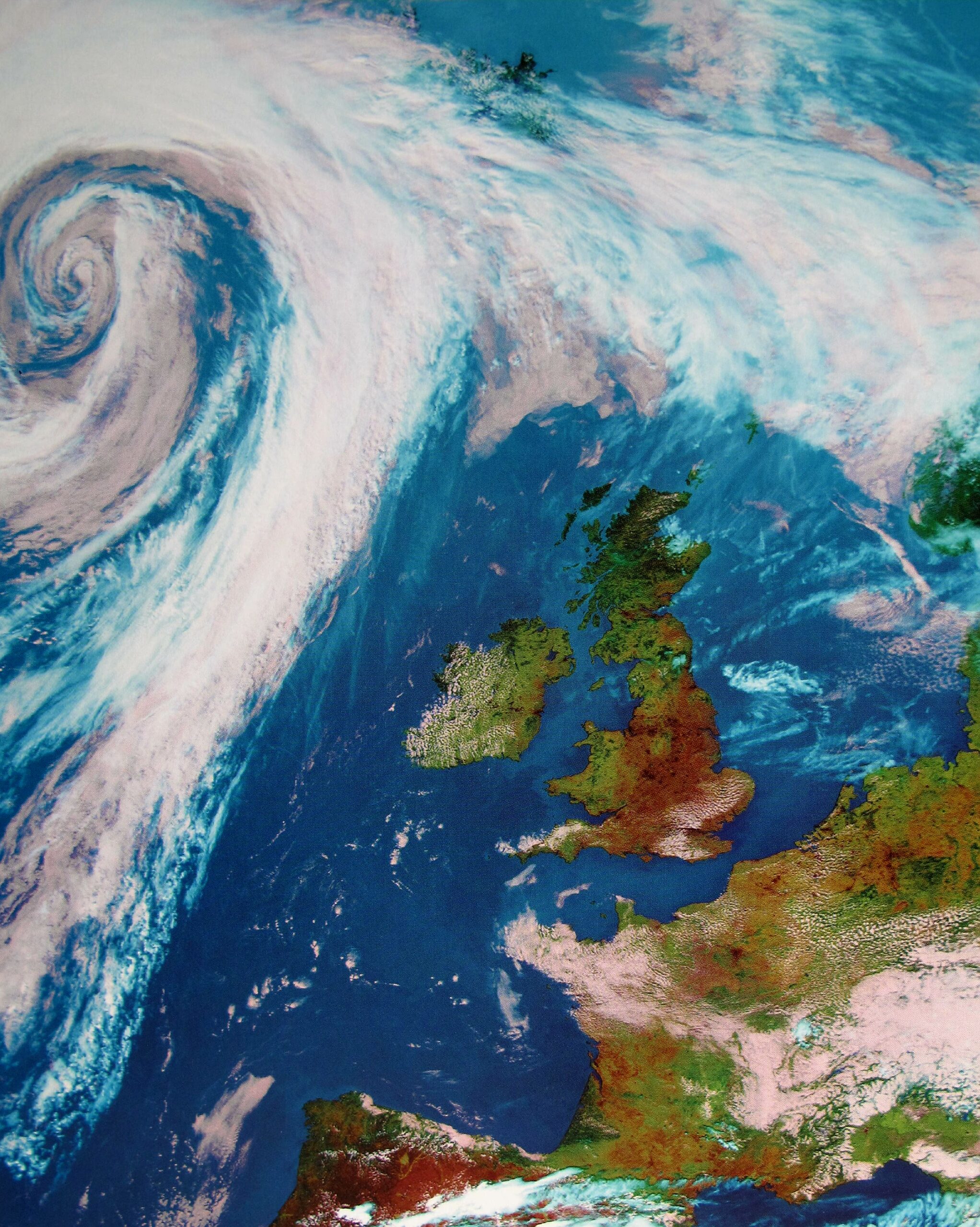
Earth is blanketed by gases, ranging up to 600 miles above us, which we call the atmosphere. These gases literally allow life to flourish; protecting us from the searing heat and radiation of the sun and the icy blasts of night. There are 5 main layers of our atmosphere, most of which are calm and unchanging. But the lowest layer, the Troposphere, filling just 3 to 10 miles above sea level, and where we live and breathe, is the layer where all our turbulent weather occurs. This is because the troposphere contains the most water vapour, without which we would have no clouds, rain, snow, hail etc. and therefore no weather. Vast swirling clouds all across the earth are easily visible from space, showing the constant motion of gases in this layer, with the resulting changeable weather. I have included a satellite image, showing clear skies over the UK due to a high pressure anti cyclone, and the swirly clouds of a low pressure depression, over the Atlantic. Better than a wet finger in the air!
The atmosphere is on the move because of the wind, which is simply air in motion. Warm air is lighter than cool air, so warm air rises and cool air sinks. Winds blow wherever there is a difference in air temperature and pressure, and always flow from high to low pressure. We have both global and local wind systems. Global wind systems move warm air from the equator to the poles, with cold air sinking and moving towards the equator, thereby keeping world temperatures in balance. Nature likes to balance things as much as possible! Because the earth spins, winds north of the equator bend to the right, and winds south of the equator bend to the left, known as the Coriolis effect. The UK has a mainly southwesterly wind direction, which helps our temperate climate.
Most of us will have heard of the Jet Stream, which is sometimes helpfully added to the weather graphics we see on TV. The Jet stream is a well defined zone of very powerful, narrow belts of winds that develop where there are extreme temperature contrasts in the atmosphere. They are key to the development and movement of low pressure systems. They can blow in excess of 480 miles an hour, with this record speed recorded above South Uist in the Scottish Highlands in December 1967! These winds occur at the junction between our troposphere and the next layer up, the stratosphere, and can be thousands of kilometres long, but just a few kilometres deep. Because they are so powerful, the position of the Jet Stream around the UK makes a huge difference to what weather we experience, also blocking warmer or cooler conditions depending on their position. If these strong winds get ‘stuck’ then we are stuck with whatever weather conditions we have, until they change direction. That makes me think about Mary Poppins.....
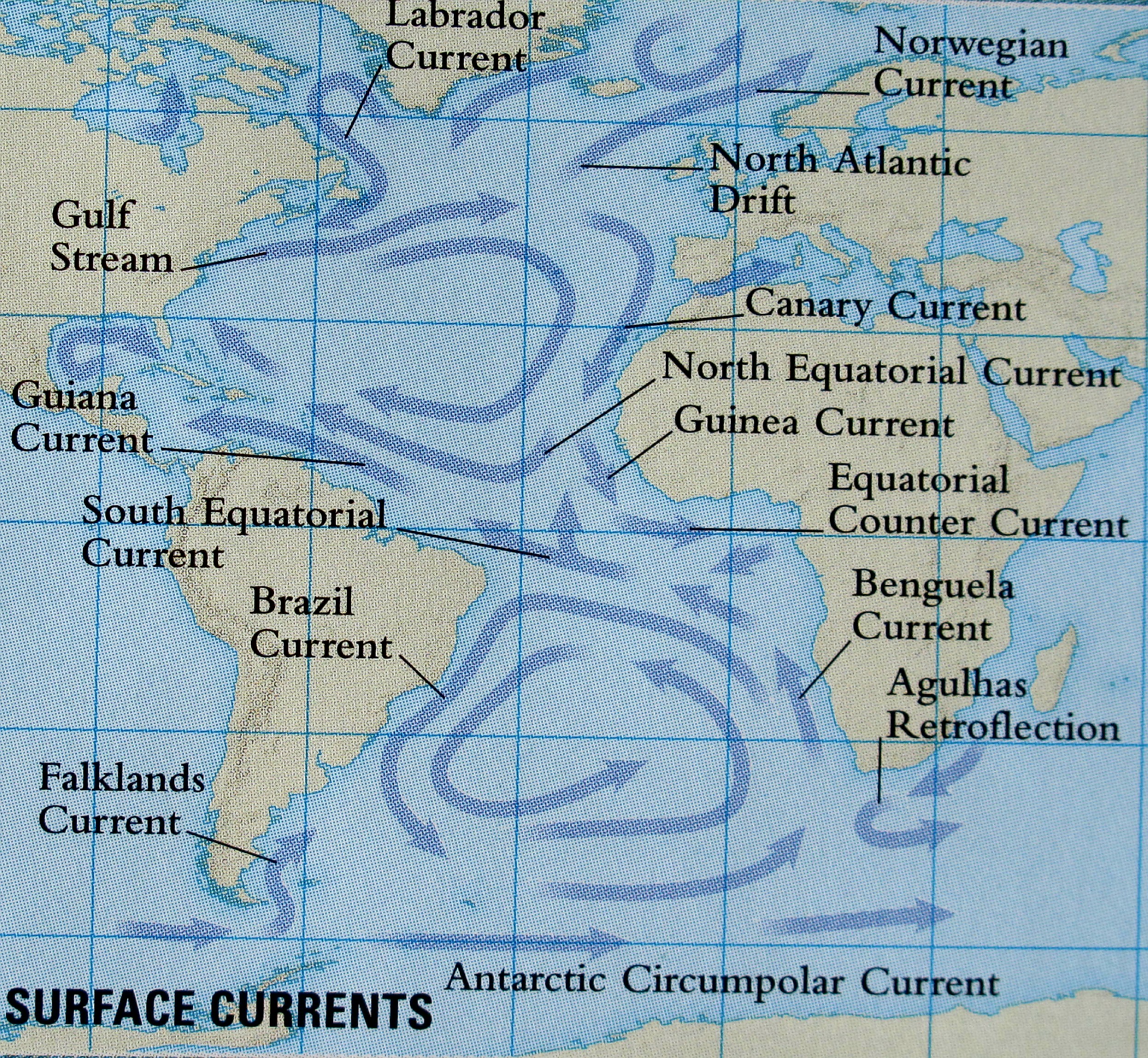
Oceans cover 71 % of the earths’ surface and ocean currents are hugely influential on global weather. As a small island we are especially affected by these forces. Our latitude means we should have a much colder climate than we have, but thanks to the ocean circulations, surface currents and winds that surround our shores we have a more temperate climate. The Gulf Stream is a lovely, strong and warm current of water, that starts in the Caribbean Sea, travels up the eastern coast of America and then crosses the Atlantic Sea to our shores. The maximum Atlantic Sea temperature occurs in September, so our land mass benefits from air blowing across these relatively warm seas in autumn and winter, making us much warmer than other countries, e.g. Siberia, who are on the same latitude as us.
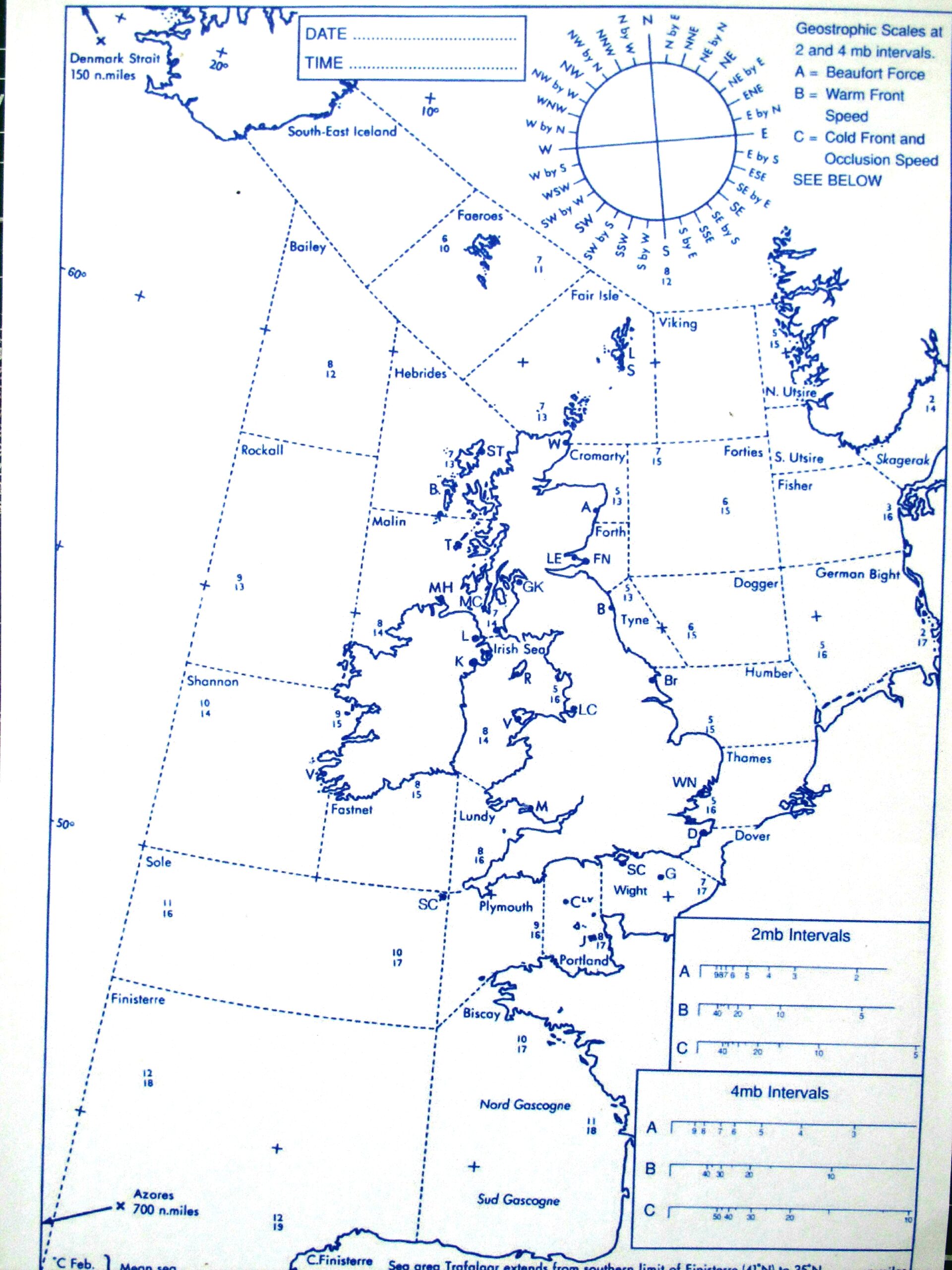
As a sea faring little island, a good understanding of our weather is an essential aspect of safety at sea. I have included a nautical map, used in the past to note the state of the seas around our shores, and I still love listening to the daily shipping forecast on the radio. It sounds almost musical to me, and remains an important service.
Occasional but huge global phenomena also affect us here in the UK, such as volcanic eruptions and El Nino. Large volcanic eruptions have a huge impact on the weather, even across the globe. Vast quantities of dust, ash, gas and sulphur dioxide droplets combine together and reflect incoming radiation from the sun back into the atmosphere, which can reduce the temperature by as much as 5OF/ 3OC. Water vapour also reacts with sulphur dioxide to produce a dense haze which can last for years in the stratosphere, cooling the lower troposphere layer we live next to. We were affected by an eruption in Iceland I think, not too long ago.
El Nino is a period of unusually high sea surface temperatures in the Pacific Ocean, along the coasts of North and South America. El Nino usually grows slowly over several months and seasons, occurring every 3 to 11 years, with varied intensity. There is much better tracking of these changes, but the phenomenon is still not fully understood. It all relates to changes in the strength and direction of the trade winds, which then affect ocean currents and surface temperatures. Warm currents that usually travel towards the western Pacific reverse, and travel eastwards, causing huge disruption to weather in the tropics, but with far less effect here. We often have more wet and windy weather after a strong El Nino year.
Spring starts, meteorologically, on March 1st, and we usually have turbulent weather through this month, as in the saying ‘In like a lion, and out like a lamb’. We have very changeable weather all year really, all down to where we sit geographically in the world.
Our small island sits between the Atlantic sea and the large landmass of Europe, with Iceland above us and Africa below. This means that we are sitting underneath 5 main air masses, all with their distinct weather features. A weather front is where those air masses meet, with resulting turbulence as they each try to dominate the weather. Each air mass brings us different conditions: Maritime refers to the sea, and Continental to land.
The Arctic Maritime air mass brings cold, wet, snowy conditions.
The Polar Maritime brings cold and wet conditions.
The Polar Continental brings cold air in winter, hot air in summer
The Tropical Continental brings hot air in summer
The Tropical Maritime brings warm, moist air, rain and wind.
So, we have lots to contend with, which all makes for our famously mercurial weather, whatever the season!
As well as global influences, local topography affects our weather, and we all know what a bracing sea breeze feels like. I miss the sea.
Here are a few familiar words used in local forecasts, with a brief reminder of their meaning:
Cirrus – high, wispy clouds. Cold front – leading edge of cold air. Cumulonimbus – deep cumulus cloud that brings thunderstorms. Frontal depression – travelling low pressure disturbance with either warm or cold fronts. Isobar – contour of constant atmospheric pressure at sea level, and drawn as lines on weather maps that link two areas with equal pressure. When these lines are close together, they indicate strong windy weather. Ridge – an area of high pressure, formed from a larger anticyclone. Thermal - a plume of relatively warm air that rises through a cooler environment. Trough – an elongated region of low pressure, often with associated wind shift. Warm front – the leading edge of the warm, moist air in a frontal depression. There are many more to learn.......
I for one am delighted to live where we do have seasons, even if they seem to be less distinct than in my childhood. That may be due to rosy memory, but it is also the very real effects of climate change and pollution. I hope you have enjoyed reading more about the underlying factors that help to determine our weather, and that you also enjoy this burgeoning spring season, whatever it chucks at us.
Click here for a downloadable pdf version of Our Weather
© Jan Flamank 1st March 2021. All rights reserved. Images used in the document have been sourced free for use in this social, educational, non-commercial setting